Workshop 5 (October 29-30, 2012):
Participating Organizations:
Hydrogeodesy Tutorial (4 hours, day and time to be determined):
|
|

|
IGCP 565 Workshop 5: Water Security for Africa: Bringing Together Research, Monitoring, and ManagingOctober 29-30, 2012 |
|  |
Exploring uncertainty in the water resources estimation chain in southern Africa
E. Kapangaziwiri and J. Mwenge Kahinda
CSIR, Natural Resources and Environment, PO Box 395, Pretoria 0001, South Africa
An uncertainty framework for model application and evaluation in the Southern African Development Community (SADC) region was proposed. The framework should ensure commonality and consistency of approaches to water resources estimation, thereby creating a sound scientific basis for understanding resources’ dynamics, fostering cooperation and the realisation of peace dividends within the region. Figure 1 shows a framework for model application, that explicitly incorporates uncertainty, that has initially been developed and tested in South African basins (Kapangaziwiri et al., 2009; Kapangaziwiri, 2010). The project seeks to introduce this framework for use in southern African basins under different conditions of climate, topography, geology, soils, vegetation, data availability and quality.
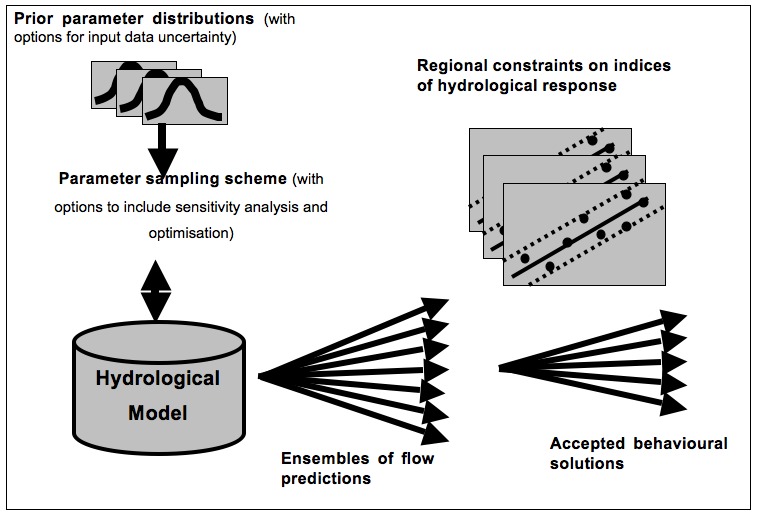
Figure 1. The model independent model application and evaluation framework that can be used in southern Africa (Kapangaziwiri et al., 2009).
This framework accounts for the various constraints expected to exist in the region related to, inter alia, data availability and accuracy, model preferences, capacity or willingness of practitioners to adopt new methods and access to specialised software. The framework can be used with any model structure and works in both gauged and ungauged basins. The basic tenet of the framework is the explicit accounting for the uncertainty, related to either the input data or parameter estimation, and to then propagate this uncertainty through the model to generate an output ensemble of probable flow predictions. However, not all of these outputs will necessarily be consistent (i.e. behavioural, Beven, 2006) with expected hydrological behaviour and therefore acceptable.
The filtering necessary to identify which of the model outputs are behavioural either is achieved by the use of historical observations where available, or regionalised indices of hydrological behaviour in both gauged and ungauged basins. Such indices are expected to cover the range of hydrological regime characteristics (magnitude, frequency and duration) and some could be shared by different models, while other may be specific to certain model types (i.e. indices based on daily flow regime variations would be relevant to daily models only). The conditioning and constraining methods should be based on measurable common properties of simulated data and be thus useable with any model structure to ensure the compatibility of results. The use of indices is significant since they can provide insight into the functions of a catchment and are solid basis for a hydrologically relevant catchment assessment. This is especially so when observed data are unavailable or insufficient. This project seeks to explore possible means of conditioning and constraining model outputs in both the gauged and ungauged basins of the southern Africa region. While data required for the development of indices may not be available uniformly across the region, there has been a recent rise in the amount of hydrological information generated by means of satellite gravimetric techniques such as the Gravity Recovery and Climate Experiment (GRACE) and other remote sensing platforms (e.g. TRMM, MODIS), which can potentially be used. These remotely-sensed data can be used to both improve parameter estimation and constrain model outputs. The tests for this approach are yet to be realised as the quest for relevant data is still on going. It is also expected that direct data assimilation into the models would be tested in order to improve modelling exercise and modelling outputs. For this project, a revised semi-distributed version of the Pitman (Pitman, 1973) model that incorporates surface and groundwater interactions (Hughes et al., 2006) has been used.
This presentation shows some of the results based on limited historical observations. One conclusion is that there is still a lot of uncertainty in the model outputs, which need to be resolved. It is envisaged that improved data from earth observation techniques would improve modelling results and, consequently, decision making.