
|
IGCP 565 Workshop 3:
Separating Hydrological and Tectonic Signals in Geodetic Observations
Reno, Nevada, October 11-13, 2010 |

|
Objective
The workshop has the objective to make progress towards improved applicability of geodetic observations for hydrological and global change studies. The focus of this workshop will be on the separation of hydrological and tectonic signals in geodetic observations of Earth's time-variable gravity field, surface displacements, and rotation. In regions like the Southwestern U.S., the Mediterranean, Northern India, East Africa, and large parts of East Asia, tectonic processes and changes in land water storage produce overlapping signals in geodetic observations. At the same time, these regions experience water scarcity and would benefit from improved water management informed by improved data on water storage changes. In order to fully utilize the potential of geodetic observations to provide estimates of land water storage changes in these regions, the tectonic and hydrological signals need to be separated. In other regions, geodetic signals of present-day changes in water storage are superimposed by contributions from large past changes in glaciers, ice sheets and large lakes hampering the use of geodetic observations as constraints for current climate change impacts.
Scope
The workshop will consider processes in the Earth system that impact geodetic observations on sub-daily to secular time scales and on sub-kilometer to global spatial scales. As illustrated in the figure below, on the solid earth side, these processes include volcanic and geothermal activities, post-seismic deformation, the response to surface loading, plate boundaries, and global geodynamics. In the fluid envelope, all mass redistribution in atmosphere, oceans, land water storage, and the cryosphere need to be considered. In scope, the workshop will focus on a few selected regions, where large tectonic signals have the potential to bias the hydrological information. Focal regions will include the Southwestern U.S., where the EarthScope program provides insight into the relevant tectonic processes, East Africa, where an extension of the AfricaArray may lead to improved observations, and Northwest India, where GRACE has indicated large changes in land water storage with the potential for a major water crisis.
Goals
The workshop will review the current state knowledge with respect to the geodetic fingerprints of the tectonic and hydrological processes, and the main challenges in modeling and separating the various contributions will be identified. The workshop will aim to make progress towards an agenda to address these challenges through focused research projects.
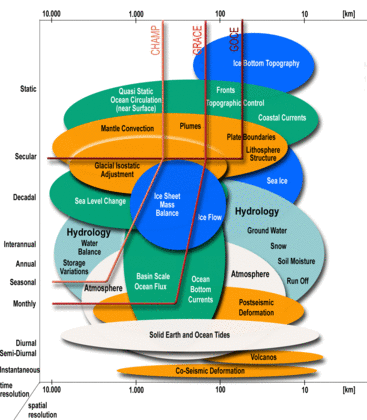 |
Geodetic observations carry signals of a wide range of processes in the solid Earth and its fluid envelope. The geodetic fingerprints of these processes have temporal time scales from instantaneous to secular, and spatial time scales from local point movements to global. The figure illustrates the spatial and temporal scales for gravity, and a similar figure applies to surface displacements as well. From Ilk et al. (2005).
|
|